Henri Is Downgraded to Tropical Storm as Northeast Braces for Landfall


Thick bands of heavy rain and powerfully snapping winds began to batter the East Coast on Sunday morning, signaling the imminent arrival of Henri.
The hurricane was downgraded to a tropical storm just before its expected landfall.
With maximum sustained winds of 70 miles per hour, the storm’s center will likely hit land around midday Sunday over eastern Long Island or southern New England, the National Weather Service said.
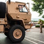
With National Guard troops standing ready to clear debris and make high-water rescues in New York, Connecticut and Massachusetts, forecasters warned that Henri could produce dangerous storm surges of up to five feet, swamping coastal communities with wind-driven seawater.
The last hurricane to make landfall on Long Island was Gloria in 1985 and the last one to make landfall in New England was Bob in 1991. Gloria closed schools and businesses, flooded low-lying areas and caused millions of dollars in damage. Bob killed at least a dozen people, brought down power lines and wrecked houses as neighborhoods flooded.
Mindful of the damage from those storms and the difficulty of precisely predicting Henri’s path, officials in New York and New England canceled events and activities planned for Sunday and urged tourists to leave beach towns. Hardware stores were filled with customers snapping up batteries and flashlights in anticipation of power outages.
With eight inches of rain possible in Connecticut, the coastal towns of New Haven, Branford, Guilford and Groton recommended that residents on streets closest to the water voluntarily evacuate. New York officials warned of possible dangerous storm surges in parts of the Bronx and northern Queens.
In preparation for the storm, New York suspended outdoor dining and closed beaches for swimming for Sunday, and the Metropolitan Transportation Authority was preparing to cancel some Long Island Rail Road service.
There were voluntary evacuations on Saturday on Fire Island, a narrow barrier island off the southern shore of Long Island. By 6 p.m., Edwin Pabon, 51, who works at a barbershop on Fire island, was on a packed ferry on his way home to Manhattan. The ferries had been full since early morning, he said.
Mr. Pabon was taking precautions by closing his shop and heading to Manhattan, but he felt that the response was overblown.
“I am not scared of a hurricane,” he said. “I am from Puerto Rico, I grew up with hurricanes,” he said, adding, “I feel like people need to relax a little.”
At East Side Market Place in Providence, R.I., shoppers were leaving on Saturday with bags of food and packages of water bottles. Storm surge alerts beeped on smartphones, issuing digitally synchronized warnings.
Randy Henri Heartfield, who said he had been paying attention to the storm because of his middle name, and two other students at Rhode Island School of Design were shopping for what could be their first hurricane.
They were planning to buy lots of water, ice to keep their produce fresh, and perhaps some buckets in case the ceiling of their second-floor apartment leaks.
John O’Flaherty, executive director of Community Boating Center in Providence, said it took 20 people more than an entire day to haul all 30 of the center’s sailboats out of the water.
But Mr. O’Flaherty, who has been at the helm of the boating center for 16 years and has weathered his fair share of storms, was not taking any chances.
“Whether they are big or not, you have to prepare for them,” he said.

NEW BEDFORD, Mass. — Against gathering winds, the 400-ton steel doors connecting the city’s hurricane barrier groaned into place Sunday morning, sealing off the region’s largest fishing port as southern New England braced for the impending storm. The New Bedford Hurricane Barrier hadn’t closed because of a storm since Sandy nine years ago.
Those able to make it inside were packed tight, wooden sailboats and lavish yachts jammed beside the rusted fishing vessels more typical of this industrial harbor, bobbing in the nervous swells. Those still at sea were expected to find another port.
“Once it’s closed, it’s closed,” said Justin Poulsen, director of the New Bedford Port Authority. “You can’t underestimate this kind of storm.”
Tropical Storm Henri is expected to hit New Bedford Sunday morning, bringing heavy rain, 50 mile-an-hour winds and surges between three to five feet.
The New Bedford Port Authority announced that it was at capacity by midday Saturday. Vessels hailing from New Jersey, Rhode Island, New York and Massachusetts were stacked six deep along the docks. Many had cut their trips short.
“You want to be protected when nature turns ugly,” said Walter Ramos, 59, who powered his 55-foot sloop, Beneteau, from the exposed port in Dartmouth to New Bedford.
John Alvernaz, 55, a deckhand on the William Lee, a roughly 75-foot scalloper out of New Bedford, said their crew was about 100 miles offshore Friday afternoon when they felt the winds pick up. They had caught about a quarter of their 18,000 pound quota when the captain made the call to steam back to port.
“A storm like this, we weren’t going to take a chance,” he said.
Nearby, a local shipyard was busy hauling out a double-decker yacht flagged from Newport, R.I. Further down the port, vacationers in bathing suits and carrying luggage streamed off the Seastreak ferry from Martha’s Vineyard, an island about 15 miles southeast.
Hotels in New Bedford were packed as tight as the docks. Weddings that had booked rooms through the weekend were canceled, and fishermen, yacht owners and power-company employees have taken their place.
“We’re New Englanders. This is what we do,” said a clerk at the New Bedford Harbor Hotel. “We buckle down and get through it.”.
— Will Sennott

Adam Sobel is a professor and director of the Initiative on Extreme Weather and Climate at Columbia University. He is an atmospheric scientist and host of the “Deep Convection” podcast.
There are some striking similarities between Tropical Storm Henri, which is forecast to make landfall along the Northeast coast this weekend, and Hurricane Sandy, which devastated parts of New York and New Jersey in 2012.
At the same time, there are some very important differences that will probably affect the track and impact of Henri. New York City, in particular, is not at great risk this time, though some forecast models still show Henri turning west and making landfall there.
There’s a reason that hurricanes rarely reach New York or New England, where none has made landfall in the 30 years since Hurricane Bob in 1991. As storms drift north, they get caught up in the prevailing winds at higher latitudes. These winds generally blow from west to east (unlike tropical winds, which generally blow the opposite way), and push hurricanes out to sea, away from the Eastern Seaboard.
Something has to break that pattern before the Northeast can get a direct hit.
What can do that? Either a high-pressure system offshore to the east of the storm, or a low-pressure system approaching from the land to the west, or both, can drive a hurricane northward rather than eastward. When those conditions occur, the south-facing parts of the coast — from Long Island to Cape Cod — become the most likely landfall area, as it is for Henri.
Similar meteorological situations have been responsible for most, if not all, of the hurricane landfalls in the area, like the 1938 “Long Island Express” storm and several hurricanes in the 1950s. Those events prompted the building of storm surge barriers in Stamford, Conn., Providence, R.I., and New Bedford, Mass.
Sandy was an extreme case. An approaching low-pressure system was strong enough to cause Sandy to revolve around it (and vice versa) as the two systems merged in what is called the Fujiwhara effect. This process strengthened Sandy and slung it westward, resulting in the “left hook” that brought the storm into the New Jersey shore at nearly a right angle. No other storm is known to have done that.
A similar configuration is developing now: An approaching upper-level low-pressure system is predicted to do a Sandy-like dance with Henri. But it doesn’t look as though the Fujiwhara effect will be powerful enough this time to sling Henri as far west as Sandy turned, nor is it likely to give Henri the strength of Sandy, which reached Category 3 at one point. (By the time Sandy came ashore, it was back down to Category 1, which Henri is predicted to be at landfall.)
Beyond that, Sandy was an extremely large storm. Its size and westward track conspired to drive a catastrophic surge of seawater into New York Harbor. With Henri looking less extreme in both respects, a major disaster for New York City and New Jersey is unlikely this time.
There are reasons to hope that Henri won’t actually be disastrous anywhere. It is forecast to slow down and weaken before landfall. But it is too early to say that with confidence.
— Adam Sobel

Henri was downgraded to a tropical storm on Sunday, but it was still expected to bring heavy rain, potential flooding and a dangerous storm surge.
Here’s how to prepare for a hurricane or tropical storm:
Before the storm
Ahead of a storm, the Federal Emergency Management Agency recommends signing up for local weather alerts and learning evacuation routes.
In the event of a power loss, the National Weather Service suggests having a battery-operated radio for news updates.
The Red Cross suggests preparing an emergency kit with the following items: water (enough for one gallon per person per day), nonperishable food, a flashlight, a first aid kit, a multipurpose tool, hand sanitizer or sanitation wipes, important personal documents, blankets and maps of the area.
FEMA also recommends preparing a “go bag” with essential items, such as medications, and securing important documents, such as financial, medical, school and legal records.
During the storm
During a storm, FEMA suggests staying away from windows in the event of high winds, and seeking shelter on the lowest level of a home in an interior room, such as a closet.
If there is flooding, FEMA says people should seek higher ground. In the event of flooding, the National Weather Service says those driving should never drive through flooded roadways. Two feet of flowing water is enough to float a vehicle.
Residents should heed guidance from local officials, and promptly follow any evacuation orders.
After the storm
Once a storm has passed, the authorities still urge drivers to avoid flooded roadways. Anyone who evacuated should wait to return until local officials say it is safe to do so.
Residents in an area affected by a storm should also avoid drinking tap water unless local officials say it is safe to use.
Source: https://www.nytimes.com/live/2021/08/22/us/hurricane-henri-updates/


