


Heavy snow expected to continue piling up in western New York after historic storm
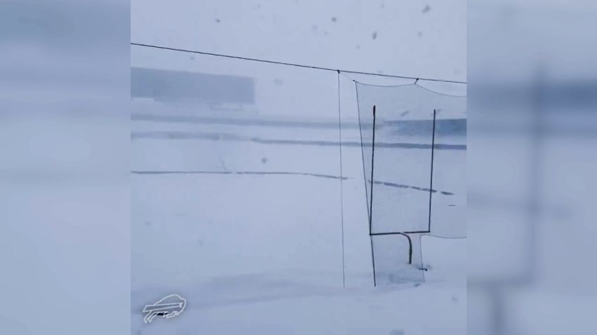
Video shows Buffalo Bills stadium buried in snow after massive storm
01:45 – Source: CNN
CNN —
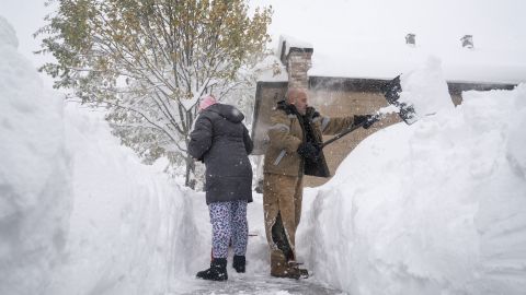
Heavy snow is expected to continue piling up in western New York state through Sunday after a historic storm saw the Buffalo area logging record snowfall totaling more than 6 feet in some areas.
Just after 11 p.m. Saturday, the National Weather Service in Buffalo issued a special weather statement warning that a band of heavy snow accompanied by high winds was creating a “burst of snow” in western New York state. The band was moving south of the Buffalo and Rochester metro areas, the weather service said.
“This band of heavy snow is producing extremely heavy snow at the rate of 2 to 3 inches per hour,” it said. “Use extra caution if you must travel … Rapid changes in visibility and potentially slick roads may lead to accidents.”
While the Buffalo area is used to dealing with heavy snowfall, this storm is delivering “much more than we usually get,” Mayor Byron Brown told CNN Saturday.
Erie County, which includes Buffalo, experienced its largest-ever amount of snowfall in a 24-hour period Saturday, according to Erie County Executive Mark Poloncarz.
Since the snow started falling, two people have died from cardiac complications related to shoveling snow and attempting to clear the ground, he said.
As the heaviest snow slid south of the greater Buffalo area into southern Erie and Chautauqua counties overnight, an additional 6 to 18 inches is possible in the region, especially across higher terrain, CNN Meteorologist Derek Van Dam said.
By Sunday morning, winds shifted more westerly, meaning the heaviest lake-effect snow bands are now south of Buffalo impacting areas from Cleveland to Dunkirk, New York. Buffalo is no longer under a lake-effect snow warning but remains under a winter weather advisory through Sunday evening for “blowing snow,” according to the weather service.
The heaviest snowfall Sunday will be east of Lake Ontario, where up to a foot of additional snow is forecast with localized areas potentially seeing even more.
Winds could gust as high as 45 mph across the Great Lakes region, which will lead to very cold conditions with temperatures feeling like single digits to slightly below zero.
Snowfall totals of more than 6 feet have been recorded in two locations, according to the weather service. Orchard Park, where the NFL’s Buffalo Bills play, picked up 77.0 inches in a 48-hour period, and Natural Bridge, just east of Watertown, picked up 72.3 inches – historic numbers for the area.
The multiday weather event has made travel in the region difficult, triggering the closing of roads, driving bans and flight cancellations the weekend before the Thanksgiving holiday.
On Saturday night, the weather service warned that the latest band would make travel conditions severe in a matter of minutes.
Nearly 400 citations have been issued to drivers who have been found violating travel bans in the region, Poloncarz, the Erie County executive, said.
“If you’re trying to enter an area where a travel ban exists, you will meet a friendly neighborhood New York State trooper who will immediately give you a ticket for violating the travel ban,” Poloncarz said.
Authorities are towing vehicles that are stuck on the side of the road or have been involved in accidents because of people traveling during the snowstorm, he said.
Air travelers haven’t been faring much better, with dozens of flights arriving and departing from Buffalo Niagara International Airport canceled as storm conditions worsened, according to the airport’s website.
The airport set a daily snowfall record of 21.5 inches Saturday, shattering the previous daily record of 7.6 inches set in 2014, the local weather office said.
This ranks as the fifth-highest single-day snowfall total on record for Buffalo and the second-highest single-day snowfall total for the month of November.
This month is already Buffalo’s third-snowiest November at the airport thanks to the storm, according to the local weather service office.
New York Gov. Kathy Hochul touted the state’s storm preparedness Saturday afternoon and said crews have been working tirelessly to manage the situation.
“This is the effort we’ve brought together: bringing resources, people, equipment from all over the state of New York. And because we were so preemptive in this strike, we were able to avert many tragedies,” Hochul said.
She thanked western New Yorkers for shutting down major highways, implementing travel bans and staying home before the snow started to fall, which helped prevent accidents, protect human life and ensure roads are safe and clear for emergency services, she said.
Hochul said she is doubling the number of New York National Guard members on the ground in Erie County to check on residents and help with snow removal.
She is also signing a request for federal reimbursement through a Federal Emergency Disaster Declaration.
Nearly 6 million people across four Great Lakes states (Michigan, Ohio, Pennsylvania, and New York) will remain under winter weather alerts through much of Sunday.
Brown, the Buffalo mayor, said the city could return to “some sense of normalcy” by Monday or Tuesday, assuming the worst of the storm passes through Sunday.
“This has been a very unpredictable storm with the snow bands moving, back and forth, north to south,” Brown said. “The snow has come down very fast, very wet, very heavy.”
Source: https://www.cnn.com/2022/11/20/weather/buffalo-new-york-great-lakes-snowstorm-sunday/index.html
