Texas Is Hit by Damaging Winds as Southeast Braces for Severe Weather

Homes, trees and a high school in Texas were damaged by strong winds on Monday. The weather system is expected to move over Louisiana and Mississippi on Tuesday, forecasters said.


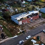
A storm system capable of producing floods, isolated tornadoes and hailstones the size of Ping-Pong balls was moving eastward across Texas on Tuesday morning, hours after high winds from the system damaged homes, downed trees and ripped a roof off a high school.
Several tornadoes roared through Central Texas beginning in the late afternoon on Monday. Tornadic winds in and around Austin, the state capital, overturned an 18-wheeler. In Elgin, about 25 miles east of the city, a mobile home was tossed onto the top of a building.
Images of destroyed homes, broken trees and streets littered with debris in Jacksboro, about 90 miles northwest of Dallas, circulated widely on social media.
As of early Tuesday, there were torrential rains in the Austin area, and a flash-flood warning there was in effect until 3:45 a.m. About 50,000 customers across Texas, mostly in the northeastern part of the state, were without electricity, according to PowerOutage.us, a website that aggregates data from utilities across the United States.
Tornado watches were in effect until 8 a.m. for swaths of Texas that included Houston and encompassed a population of more than 7.5 million people. The National Weather Service said that scattered wind gusts up to 75 miles per hour, a couple of tornadoes and isolated hailstorms were possible.
Other counties in Texas, southwest Arkansas and northwest Louisiana were under tornado watches until 3 a.m., the Weather Service said.
While thunderstorms are common in the region throughout the year, severe weather reaches its peak during March, April and May.
As a strong front producing rain and snow over the Rockies moves east by Tuesday, a wave of low pressure will develop over the Southern High Plains, the Weather Service said on Monday. That system will pull moisture northward over the plains and the Mississippi Valley from the Gulf of Mexico.
The rolling storms could produce frequent lightning, heavy wind gusts, hail, tornadoes and excessive rainfall that could lead to flash flooding, meteorologists said.
Here is a glance at the forecast by region.
Stormy weather began on Monday afternoon in Texas.
Several homes and structures in central Texas were destroyed by heavy winds on Monday, Gov. Greg Abbott said at an evening news conference about 40 miles north of Austin. No deaths had been reported so far, he said.
Judge Bill Gravell, Jr., of Williamson County, who joined the governor at the event, said that several people had been injured while sheltering at home from the storm, but officials did not provide specific numbers.
The storm also knocked down power lines, creating dangerous conditions, the judge said. As a result, he said, electricity in parts of the county would be turned off “in order to protect the first-responders and in order to protect those doing the repairs needed.” He did not say when electricity would be restored.
The winds seriously damaged a school in north-central Texas.
“There’s no roof left,” Starla Sanders, the principal of Jacksboro High School, told the local television station WFAA. The school ended “a little bit early” so that students could get home safely, and no injuries were reported, Ms. Sanders said.
She said she had heard reports that her home had been damaged, too. “I haven’t been out there,’’ Ms. Sanders added. “The road’s blocked, but that’s what people say — that there’s not much left of my own house.”
Portions of Texas could receive up to four inches of rain through Tuesday evening, with some areas receiving more rain along with possible street flooding, the Weather Service in Houston said.
While there was uncertainty about the timing of the storms and which areas would receive the heaviest rain, meteorologists told residents to prepare.
Storms will move to the Southeast on Tuesday.
As the storms push eastward on Tuesday, more than two million people in portions of Louisiana and Mississippi could face severe weather. Cities in the path of the storms include Baton Rouge, La., and Jackson, Miss.
The main threat on Tuesday will be tornadoes and damaging winds before and after the storm, the Weather Service in New Orleans said, adding that hail greater than an inch in diameter could develop. Up to three inches of rain is forecast. A tornado outbreak is also likely on Tuesday.
Areas in Mississippi may see winds as strong as 70 miles per hour and hail the size of golf balls, forecasters said.
About three inches of rain is expected in Memphis. Areas to the east, including Georgia, are expected to receive less rain.
Parts of the East Coast will have a slight risk for severe weather beginning Wednesday.
Mike Ives and David Montgomery contributed reporting.
Source: https://www.nytimes.com/2022/03/21/us/severe-weather-forecast-tornadoes.html


