


Apple Maps is getting some new features: Here’s what that means for your iPhone

Apple Maps first launched in 2012 and became the default map app on iPhones everywhere. Its first incarnation wasn’t all that well-received, and since then Apple’s been pushing out years of steady updates to get it on track. Now, Apple has rolled out the all-new Maps — a 3D experience with a considerable amount of visual details, improved accuracy and many quality-of-life upgrades.
In order to unpack the latest Apple Maps improvements that you should know about, CNN Underscored got to chat exclusively with David Dorn, product lead, and Meg Frost, design lead, at Apple Maps. From 3D buildings in cities to clearer navigation instructions, here’s everything you need to know.
A whole new look for better navigation and accessibility
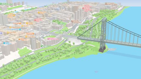
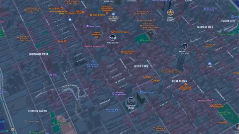
Apple takes a 3D approach with the map that starts in the globe view and extends to city streets. And whether you’re navigating the suburban roads of New Jersey, traveling over the George Washington Bridge to the Bronx or maybe taking a cross-country trek along Route 66, it’s reflected throughout. As Dorn and Frost explained, these newer elements — buildings, accurate road styles and climate-appropriate trees — are placed on top of the map.
“Before the new map, we had a two-dimensional product and we really had a flat representation of the world. So we took the opportunity to create a realistic globe that accurately represents the sizes of countries in 3D,” said Frost.
Viewing on a larger-screened Apple device has additional perks, with new capabilities such as exploration or educational tasks on an iPad. You can split-screen and capture screenshots to create a virtual tour or follow a guide for some of the cities. One standout feature is Flyover; for select landmarks, like the Freedom Tower in NYC or the Golden Gate Bridge in San Francisco, you can get a virtual tour of the site. It’s reminiscent of Google Earth in this mode.
There’s a nighttime view baked into 3D, and Apple’s design team took the time to customize the 3D builds with lights for a starry night look. It looks great on a 12.9-inch iPad Pro.
So what’s new with this 3D approach on top of an accurate map? Well, it’s really about the details. When navigating somewhere on an iPhone, you’ll notice that you’ll see clearer details about lanes in a road. Lanes are depicted accurately — with road markings — and intersections show crosswalks. It not only helps with accessibility since you’ll know those elements are there, but also extends to knowing what lane you need and how to get there properly. Even neater, you’ll see proper elevation when navigating complex highways that have ground-level roads with overpasses that intersect.
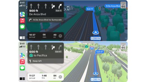
It’s been on the iPhone for navigating by car, bike, walk and transit since iOS 15 launched in September, but now this updated look is finally hitting CarPlay. The new environmental elements, along with road details, make for a more effortless navigation experience filled with — hopefully — fewer wrong turns or screaming at the GPS.
“At a glance, drivers can understand a complex intersection more quickly than ever before,” said Frost. “And that detail helps with that split-second decision of which turn they’re going to make. So we want it to be both safer and visually satisfying to navigate.”
Detailed landmarks for educational use — or just for fun
Arguably, the biggest feature of the new Maps is what Apple calls landmarks, in addition to the updated look of streets and trees — yes, trees. While we didn’t speak about this in this call, much has been said about Apple adding climate-accurate and environment-accurate trees to the maps. It’s a nice approach and a leg up on other mapping services.
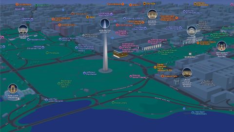
But the real story is that Apple modeled key buildings and elements in cities. The team worked with locals to pick structures that would be represented in a hyper-accurate way. Once Dorn’s team decided on the landmark, Frost’s team then handcrafted it — manually.
“We pick the amount of detail we find appropriate and create a 3D mesh of the building landmark itself. And we apply it to the base map,” explained Frost.

Radio City Music Hall in New York City is complete with proper-colored lighting. The Arch, trees and pond in Washington Square Park look pristine. And the Philadelphia Museum of Art is complete with a statue of Rocky at the bottom. In DC, Apple’s recreation of the national monuments and memorials can be used on a Mac or iPad in class for educational purposes.
It’s also a first for major digital maps — Waze and Google Maps don’t go as far or as detailed with 3D recreations of these elements.
Apple certainly established a better reputation around Apple Maps with its most recent updates. It’s more accurate and this year got a real big glow-up — including some useful features that go beyond the big 3D upgrade.
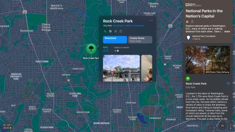
With Transit, you can pin your favorite and most frequented lines. You can also now rate and review local establishments like restaurants or stores. This update arrives in the card that appears when you search for a location and tap for more. Dorn noted this is one of the most-used portions of Maps, and it was clear that this update gives you more critical info at once and aims to make navigation easier. It also extends to discovery with a feature called Guides. Apple worked with editorial partners to help you get to know a city — discovering things to do or finding some restaurants to check off a bucket list.
And if you have an iPhone and Apple Watch, you can use Apple Maps for a hands-free experience. Thanks to haptic feedback on your wrist, you can know to make a left or a right turn when using walking directions, as the watch will subtly tap on your wrist. It’s been a favorite feature of ours since wearing the watch.
Frost expanded on the Apple Watch experience as an excellent way to navigate while cycling. Apple Maps factors in elevation — since you’ll need to pedal harder on a hill — when navigating for a bike. And you can get that whole experience on your wrist with haptic feedback that won’t require you to take your eyes off the road.
If you’re using the HomePod Mini — our runner-up pick for a smart speaker — you can start the navigation journey from home. Ask Siri for a place, then ask to send the directions to your iPhone and you’re off to the races. It’s similar to what can be done with a Google home and an Android phone. It’s pretty handy.
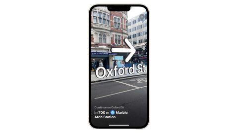
Additionally, if you ever get lost, you can use AR walking directions in select cities in the United States. It’s similar to finding a lost AirTag, but you’ll point your iPhone around you and it will display arrows, distances and directions in real-time. We’ve tried it once or twice, and it does indeed work.
The best integration, though, is that you can easily share your ETA with a contact while traveling. It’s baked into CarPlay or navigating on an iPhone, but you can also ask Siri to share it. Your location shows up in that user’s Maps application to follow along until you reach your destination.
Dorn described the advantages as a three-pronged approach for why Apple Maps should at least be considered as your map of choice. Firstly, Apple is making a large investment into Maps to continue making it better. Privacy is central to it, in that you don’t need to make a separate account and they aren’t tracking your location for data purposes. Third is the design and ecosystem that Maps plays into. The integration with other Apple devices and services is a key aspect of this service.
But Apple Maps isn’t the only choice for users. Google Maps and Waze are two leading mapping options and both excel with unique features. Google’s service works across platforms and has offered straightforward navigation for any travel mode for a while. Waze, meanwhile, focuses on the community and works to get you around traffic in real time. They go beyond a traditional GPS by using other members in the app to figure out ways around. The point is that there are many players in this space, and each is trying to craft an accurate map with some useful features.
And if Apple Maps is doing its job right, Dorn says it can remove a “cognitive load” off of the user and let you focus on the road. Precise details and accurate environments can certainly help get you on the right path for that.
Source: https://www.cnn.com/2021/12/22/cnn-underscored/apple-maps-update-3d-landmarks-navigation/index.html?iid=CNNUnderscoredHPcontainer


