


Tropical Storm Mindy Hits the Florida Panhandle
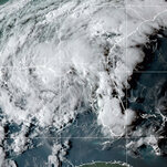

Tropical Storm Mindy hit the Florida Panhandle on Wednesday night, just hours after it formed in the Gulf of Mexico as the 13th named storm of the 2021 Atlantic hurricane season.
Mindy made landfall on St. Vincent Island, Fla., roughly 100 miles southwest of Tallahassee, according to the National Weather Service.
It was expected to bring heavy rainfall to the Florida Panhandle, southern Georgia and coastal South Carolina before moving into the western Atlantic Ocean by Thursday. Two to four inches of rain were expected, with six inches possible in some areas.
On Thursday morning, the Weather Service issued a flash-flood warning for Tallahassee and Bradfordville, both in Leon County, and Midway in Gadsden County. It also expanded its flood watch into parts of south-central Georgia.
“Be especially wary in heavy rain at night,” the Weather Service said on Twitter. “If you must go out and encounter flooded roads, turn around don’t drown!”
The storm was producing maximum sustained winds of nearly 45 miles per hour, with some stronger gusts, the Weather Service said, as it urged people to secure outdoor items like trash cans and patio furniture.
In addition to flooding, there is also the possibility of isolated tornadoes over the Panhandle. Forecasters also warned of pea-sized hail.
“While we are not expecting widespread, significant damage, there is still a chance for flash flooding, strong winds, tornadoes and severe thunderstorms,” Mayor Lenny Curry of Jacksonville, Fla., said in a statement. “While we are no stranger to these conditions, it’s important that our citizens stay alert.”
In the Atlantic Ocean, Hurricane Larry continued its 16 mile per hour advance toward Bermuda and threatened to bring dangerous swells to the East Coast of the United States.
It has been a dizzying few weeks for meteorologists who have monitored several named storms that formed in quick succession in the Atlantic, bringing stormy weather, flooding and damaging winds to parts of the United States and the Caribbean.
In addition to Ida, which battered Louisiana as a Category 4 hurricane on Aug. 29 before its remnants brought deadly flooding to the New York area, there were also Julian and Kate, both of which quickly fizzled out within a day.
How to Decode Hurricane Season Terms
How to Decode Hurricane Season Terms


Karen Zraick and Christina CaronReporting on the weather 🌬️

What is “landfall”? And what are you truly facing when you’re in the eye of the storm?
During hurricane season, news coverage and forecasts can include a host of confusing terms. Let’s take a look at what they mean →


Not long before them, in mid-August, Tropical Storm Fred made landfall in the Florida Panhandle and Hurricane Grace hit Haiti and Mexico. Tropical Storm Henri knocked out power and brought record rainfall to the Northeastern United States on Aug. 22.
The quick succession of named storms might make it seem as if the Atlantic is spinning them up like a fast-paced conveyor belt, but their formation coincides with the peak of hurricane season.
The links between hurricanes and climate change are becoming more apparent. A warming planet can expect to see stronger hurricanes over time, and a higher incidence of the most powerful storms — though the overall number of storms could drop, because factors like stronger wind shear could keep weaker storms from forming.
Hurricanes are also becoming wetter because of more water vapor in the warmer atmosphere; scientists have suggested storms like Hurricane Harvey in 2017 produced far more rain than they would have without the human effects on climate. Also, rising sea levels are contributing to higher storm surge — the most destructive element of tropical cyclones.
A major United Nations climate report released in August warned that nations have delayed curbing their fossil-fuel emissions for so long that they can no longer stop global warming from intensifying over the next 30 years, leading to more frequent life-threatening heat waves and severe droughts. Tropical cyclones have likely become more intense over the past 40 years, the report said, a shift that cannot be explained by natural variability alone.
Ana became the first named storm of the season on May 23, making this the seventh year in a row that a named storm developed in the Atlantic before the official start of the season on June 1.
In May, scientists with the National Oceanic and Atmospheric Administration forecast that there would be 13 to 20 named storms this year, six to 10 of which would be hurricanes, and three to five major hurricanes of Category 3 or higher in the Atlantic. In early August, in a midseason update to the forecast, they continued to warn that this year’s hurricane season will be an above average one, suggesting a busy end to the season.
Matthew Rosencrans, of the National Oceanic and Atmospheric Administration, said that an updated forecast suggested that there would be 15 to 21 named storms, including seven to 10 hurricanes, by the end of the season on Nov. 30. Mindy is the 13th named storm of 2021.
Last year, there were 30 named storms, including six major hurricanes, forcing meteorologists to exhaust the alphabet for the second time and move to using Greek letters.
It was the highest number of storms on record, surpassing the 28 from 2005, and included the second-highest number of hurricanes on record.
Michael Levenson contributed reporting.
Source: https://www.nytimes.com/article/tropical-storm-mindy-hurricane.html


