


Henri Upgraded to Hurricane as It Takes Aim at Long Island
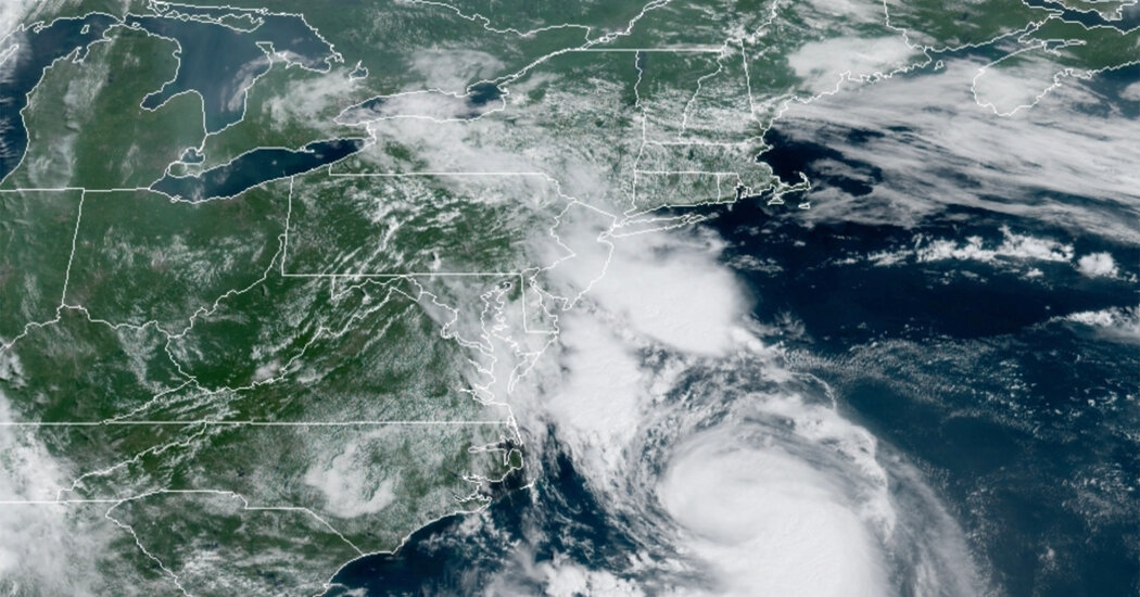

The Northeast was bracing on Saturday for the arrival of Hurricane Henri, which had gained strength in the Atlantic Ocean with winds of up to 75 miles per hour, according to the National Hurricane Center.
Hurricane Henri is expected to make landfall on Long Island or in southern New England on Sunday afternoon, the center said, adding that it is expected to be “at or near hurricane strength when it reaches the coasts” of those areas. The Category 1 storm is expected to bring several inches of rain across the Northeast and in some areas may produce a storm surge of up to five feet.
Rain and lightning that interrupted a star-studded concert in Central Park around 7:30 p.m. were signs that the outer bands of the storm had arrived in New York. Earlier in the day, Steven Bellone, the Suffolk County executive, issued a voluntary evacuation for residents and tourists on Fire Island, on the southern shore of Long Island.
There are also storm watches and warnings across the Northeast, including a hurricane warning for much of Long Island, and from New Haven, Conn., to west of Westport, Mass. A tropical storm warning is in effect for coastal New York and New Jersey, west of East Rockaway Inlet to Manasquan Inlet, including New York City.
“Preparations to protect life and property should be rushed to completion,” the center said on Saturday for those under hurricane warnings.
The National Hurricane Center cautioned that Hurricane Henri could bring the following threats:
-
Henri is expected to bring three to six inches of rain on Long Island, New England, southeastern New York, and Northern New Jersey on Sunday into Monday, with isolated totals of up to 10 inches, the center said.
-
Heavy rainfall could produce flooding in some areas.
-
Along with a storm surge of up to five feet, the center said the storm could also be “accompanied by large and dangerous waves.”
-
Once it makes landfall, the center said Henri could produce a couple of tornadoes over southern New England.
-
The center cautioned that hurricane-force winds could extend up to 45 miles outside the center of the hurricane, and tropical-storm-force winds could extend as far as 150 miles from the center.
-
Henri could also bring dangerous swells to much of the East Coast. “These swells could cause life-threatening surf and rip current conditions,” the center said.

With Hurricane Henri fast approaching on Saturday afternoon, Suffolk County officials called on visitors and residents of Fire Island, which lies on the southern shore of Long Island, to voluntarily evacuate before landfall.
“If they do not leave the island today, they will be stuck,” warned Steven Bellone, the county executive.
Mr. Bellone said that ferry travel off the island was scheduled to end at 10:40 p.m. on Saturday and that there would be no service on Sunday, when Henri is expected to make landfall as a Category 1 storm.
By 6 p.m., Edwin Pabon, 51, a barber and a partner at Handsome, a barbershop in The Pines section of the island, was on a packed ferry on his way home to Manhattan. The ferries had been full since early morning, he said.
Mr. Pabon was taking precautions closing his shop and heading to Manhattan, but he felt that the response was overblown.
“I am not scared of a hurricane. I am from Puerto Rico, I grew up with hurricanes, my island got hit by hurricane Maria and this is a Category 1,” the lowest level storm, he said. “I feel like people need to relax a little.”
He was most concerned as to whether the extensive sand berms and dunes built by the Army Corps of Engineers to shore up the island after Hurricane Sandy, would hold. “God forbid it does get bad, even if it is a Category 1, and your house is there.”
When Tropical Storm Isaias tore through the region last summer, Mr. Bellone said, Long Island saw more than 600,000 power outages — and that storm did not make a direct hit.
Scott Hirsch, the longtime owner of the Island Mermaid in Ocean Beach, a section of Fire Island, said the restaurant began to shut down early Saturday. “It’s not our first time at the dance here with stuff like this,” Mr. Hirsch said, before adding, “This one’s running on a scarier pattern.”
The storm is expected to bring heavy rain and possible flooding to cities and towns across the region, including in New York City, the Hudson Valley area, northern New Jersey and the Connecticut coast.
On Saturday night, a concert in Central Park celebrating the city’s emergence from the pandemic was abruptly halted when lightning appeared, marking the arrival of the storm’s outer bands. An announcement urged concertgoers to leave “quickly and calmly” because of severe weather.
Earlier on Saturday, one of his final days in office, Gov. Andrew M. Cuomo of New York said he was worried that because of fast-changing forecasts, there was less time for both officials and residents to prepare.
“I understand we didn’t have the buildup that we had with Superstorm Sandy,” Mr. Cuomo said, noting that New Yorkers have had only a day of warnings. “Don’t be deceived by that. It’s because the trajectory of the storm changed.”
The governor said that New Yorkers should expect flight cancellations, and that the Metropolitan Transportation Authority was preparing to cancel some Long Island Rail Road service by midnight on Saturday.
In New York City, officials warned of possible dangerous storm surges in parts of the Bronx and northern Queens. The city suspended outdoor dining and closed beaches for swimming for Sunday, and Mayor Bill de Blasio urged residents to postpone other unnecessary travel. “I’m telling all New Yorkers: Stay home tomorrow,” he said.

BOSTON — When it looked like Hurricane Henri would directly hit New England, customers converged on Adler’s Design Center & Hardware in Providence, R.I., where they bought all of the store’s kerosene lamps before moving on to flashlights and candles, said Leanne Dolloff, a cashier.
Many longtime residents of the region, however, were skeptical that the storm would be too disruptive.
“We’re New Englanders, we can handle it,” said Ms. Dolloff, 40, who remembers waking up to a floating bed in her Lowell, Mass., home when Hurricane Gloria — the last hurricane to make landfall on Long Island — swept through in 1985.
Officials were preparing in case Henri causes as much damage as Gloria or Hurricane Bob, which tore its way up the East Coast in 1991. More than a dozen people died in each storm.
Gloria was a Category 1 storm when it hit Long Island, forcing hundreds of thousands of people to evacuate, bringing down thousands of trees and leaving 1.5 million homes without power. Bob made landfall as a Category 2 storm, and millions were affected by downed trees, power outages and flooding.
Bill Shore, a longtime resident of Newport, R.I., remembers how terrifying it was to experience Bob. He had driven to New Jersey to secure a boat and then frantically drove back to save his house.
“Limbs were coming down,” he said, “but I made it back without getting clobbered.”
Mr. Shore, however, said he was not too worried about Henri. He has a generator at home and planned to keep his 30-foot sailboat in the water, although he was thinking about renting a chain saw to tidy up after the storm.
In Boston’s Seaport District, which was built upon the mud flats and salt marshes along Boston Harbor in the decades after Bob, bars and restaurants like Harpoon, Legal Sea Foods and Yankee Lobster had not made plans to close for Henri. Farther east, in the Cape Cod community of Buzzards Bay, boats were being removed from the marina but little was being done to secure gas grills or deck chairs.
Henri was expected to flood many areas already inundated from Fred.
Officials in Boston said they were building barriers around the city’s most vulnerable subway station and would suspend some transit services on Sunday. Amtrak announced that service between New York and Boston and between New Haven, Conn., and Springfield, Mass., would be canceled on Sunday.
But passengers waiting to board the ferry from Boston to Provincetown on Friday night were cautiously optimistic that their plans would not be foiled.
Gary Livolsi said he had been through a lot of nor’easters and was content simply making sure the umbrellas and cushions were not left on his patio.
“I’m hoping they’re overestimating it, as they often do,” said Susan Mahoney, who was off to spend the weekend in Provincetown but was fully prepared to stay longer if necessary. “I brought extra wine.”
Catherine McGloin and Beth Treffeisen contributed reporting.

At the tip of a barrier island running along the southern shore of the Hamptons, restaurant staff piled outdoor tables and chairs into the basement on Saturday as sport fishing boats and yachts were being brought out of soon-to-be-surging water.
Christine Oakland-Hill, the owner of Oakland’s Restaurant & Marina, was among those preparing for the worst as Hurricane Henri approached the Hamptons, the upscale vacation destination on the eastern side of Long Island. “It’s quite emotional — this is our livelihood,” she said.
When Hurricanes Sandy and Irene battered the area about a decade ago, the road to the restaurant was impassable for days. That made Ms. Oakland-Hill worried about losing business in the peak of tourist season, as Labor Day approaches.
“This is kind of it. We have 10 weeks to make it,” she said.
After days of watching Henri’s path shift, the Hamptons have emerged as a likely recipient of the storm’s strongest blow when it makes landfall on Sunday.
“The Hamptons might be the bull’s-eye in terms of the worst of Henri,” said Dominic Ramunni, a meteorologist with the National Weather Service, who added that the area could be walloped by five feet of storm surge and winds of up to 80 miles per hour.
Southampton planned to issue a voluntary evacuation order to about 6,000 people on Saturday afternoon, according to town supervisor Jay Schneiderman, who expected other towns in the Hamptons to follow its lead. “We don’t get that many hurricanes,” he said.
Another 500 people were under a voluntary evacuation warning in the town of East Hampton.
Mr. Ramunni said he hoped that people on the vulnerable peninsula — especially the area’s many visitors — would heed the warnings. “There’s a lot of new folks on the island who may not be as prepared or used to this sort of weather,” he said.
Town officials worried that long-term power outages would cripple businesses still reeling from Covid-19 closures.
“It would probably trigger an exodus of those who have other options to go back to their other homes or elsewhere,” said Peter Van Scoyoc, the East Hampton town supervisor, adding that westbound traffic out of town was already mounting on Saturday afternoon. “Any interruption of the peak tourist season is probably going to be felt by business.”

Adam Sobel is a professor and director of the Initiative on Extreme Weather and Climate at Columbia University. He is an atmospheric scientist and host of the “Deep Convection” podcast.
There are some striking similarities between Tropical Storm Henri, which is forecast to become a hurricane before making landfall along the Northeast coast this weekend, and Hurricane Sandy, which devastated parts of New York and New Jersey in 2012.
At the same time, there are some very important differences that will probably affect the track and impact of Henri. New York City, in particular, is not at great risk this time, though some forecast models still show Henri turning west and making landfall there.
There’s a reason that hurricanes rarely reach New York or New England, where none has made landfall in the 30 years since Hurricane Bob in 1991. As storms drift north, they get caught up in the prevailing winds at higher latitudes. These winds generally blow from west to east (unlike tropical winds, which generally blow the opposite way), and push hurricanes out to sea, away from the Eastern Seaboard.
Something has to break that pattern before the Northeast can get a direct hit.
What can do that? Either a high-pressure system offshore to the east of the storm, or a low-pressure system approaching from the land to the west, or both, can drive a hurricane northward rather than eastward. When those conditions occur, the south-facing parts of the coast — from Long Island to Cape Cod — become the most likely landfall area, as it is for Henri.
Similar meteorological situations have been responsible for most, if not all, of the hurricane landfalls in the area, like the 1938 “Long Island Express” storm and several hurricanes in the 1950s. Those events prompted the building of storm surge barriers in Stamford, Conn., Providence, R.I., and New Bedford, Mass.
Sandy was an extreme case. An approaching low-pressure system was strong enough to cause Sandy to revolve around it (and vice versa) as the two systems merged in what is called the Fujiwhara effect. This process strengthened Sandy and slung it westward, resulting in the “left hook” that brought the storm into the New Jersey shore at nearly a right angle. No other storm is known to have done that.
A similar configuration is developing now: An approaching upper-level low-pressure system is predicted to do a Sandy-like dance with Henri. But it doesn’t look as though the Fujiwhara effect will be powerful enough this time to sling Henri as far west as Sandy turned, nor is it likely to give Henri the strength of Sandy, which reached Category 3 at one point. (By the time Sandy came ashore, it was back down to Category 1, which Henri is predicted to be at landfall.)
Beyond that, Sandy was an extremely large storm. Its size and westward track conspired to drive a catastrophic surge of seawater into New York Harbor. With Henri looking less extreme in both respects, a major disaster for New York City and New Jersey is unlikely this time.
There are reasons to hope that Henri won’t actually be disastrous anywhere. It is forecast to slow down and weaken before landfall. But it is too early to say that with confidence.
At this point, preparation and vigilance are very much in order, especially on Long Island and across southeastern New England.
— Adam Sobel

With powerful wind gusts, heavy rainfall and dangerous flooding soon expected to affect parts of the region as Hurricane Henri nears, officials across the New York metro area and New England are warning of possible widespread power outages.
There is precedent for concern.
When Tropical Storm Isaias tore through the region last summer, nearly three million customers lost power across Connecticut, New Jersey and New York. Some saw extensive delays for its restoration — and that storm did not make a direct hit.
Hurricane Gloria, the last hurricane to make landfall on Long Island, left 1.5 million homes without power in 1985.
Here’s how power companies are preparing for Henri:
-
The storm could make landfall on Long Island, with most of the area under a hurricane watch. The utility PSEG Long Island said more than 1,200 contractors and additional crews have been brought in to help. But it warned customers that outages could last seven to 10 days — or up to two weeks if the forecast worsens.
-
Gov. Andrew M. Cuomo said that power companies in other regions of New York State that could be heavily affected by the storm, including National Grid and Con Edison, had also called in private contractors and additional personnel to help restore power. “I have told them clearly,” he said on Saturday, “this is what we pay the power companies to do, to be ready for storms.”
-
In New Jersey, the state’s largest utility, Public Service Electric & Gas, told customers to prepare for possible debris and fallen power lines but did not project an estimate for potential power losses.
-
Gov. Charlie Baker of Massachusetts warned that Henri could cause at least 100,000 residents — and possibly up to 300,000 — to lose power.
-
The utility Eversource, which provides power to about 1.2 million customers in Connecticut, said that at least half of them could be without power for several days after the hurricane. The company said it had canceled planned vacations among some staff members so that they could help in restoration efforts.

Adam Sobel is a professor and director of the Initiative on Extreme Weather and Climate at Columbia University. He is an atmospheric scientist and host of the “Deep Convection” podcast.
As the forecast for Hurricane Henri has evolved over the past few days, attention has focused on where the storm will make landfall and the risks from wind and storm surge on the coast. But the latest forecasts point to a substantial and perhaps underappreciated risk from inland flooding.
For New York State in particular, the threat is shaping up to resemble not so much Hurricane Sandy in 2012, but Hurricane Irene the previous year. That storm devastated the mountainous eastern parts of the state, as well as much of New England. Its slow motion allowed rainfall totals to escalate, filling small tributaries and then larger rivers past their banks.
Henri, too, is expected to move slowly after landfall, but its predicted path has shifted west with time. Saturday morning’s forecasts showed potential rainfall of five inches or more, not just in parts of Long Island, Connecticut and Western Massachusetts, but also in a swath of southeastern New York that includes some of the same areas hit by Irene, including the Catskill and southern Adirondack Mountains.
Some of those areas have seen a wet summer already, compounded recently by substantial rain from the remnants of Tropical Storm Fred.
Soils will be moist and unable to absorb much more water, so new rain will produce flooding sooner. Wet soils also make trees more prone to uprooting in high winds, so widespread power outages are a possibility, as is flash flooding.
— Adam Sobel

Hurricanes are defined by their powerful winds. But the storm surges they produce can often prove just as destructive in coastal communities.
Henri, which strengthened into a hurricane on Saturday morning with winds of 75 miles per hour, was expected to create dangerous storm surges in parts of Long Island, Connecticut, Massachusetts and Rhode Island.
Storm surge is defined as an abnormal rise in the ocean level generated by a storm, over and above the predicted astronomical tide. The surges are produced by ocean water moving inland, pushed by the force of the wind.
In the open ocean, hurricanes can pound the water without producing a surge. But near the coast, the shallower water is blown inland, threatening property and lives.
The deepest water will occur along the immediate coast in areas of onshore winds, where the surge will be accompanied by large and dangerous waves, the National Hurricane Center said.
Surge-related flooding depends on the timing of the surge and the tidal cycle, and can vary greatly over short distances, the center said.
In 2008, Ike, a Category 2 hurricane that made landfall near Galveston Island in Texas, produced surges of 15 to 20 feet above normal tide levels, the center said. Property damage was estimated at $24.9 billion.
Henri, a Category 1 storm, was expected to produce a storm surge of up to five feet, meaning the water could reach five feet above the normal predicted astronomical tide.
The National Hurricane Center said that areas that are placed under a storm surge warning are at risk of “life-threatening inundation.” People in those areas should heed any evacuation instructions from local officials, the center said.

Hurricane Henri strengthened on Saturday and was expected to make landfall on Long Island or southern New England on Sunday, bringing heavy rain, potential flooding and a dangerous storm surge.
Here’s how to prepare for a hurricane or tropical storm:
Before the storm
Ahead of a storm, the Federal Emergency Management Agency recommends signing up for local weather alerts and learning evacuation routes.
In the event of a power loss, the National Weather Service suggests having a battery-operated radio for news updates.
The Red Cross suggests preparing an emergency kit with the following items: water (enough for one gallon per person per day), nonperishable food, a flashlight, a first aid kit, a multipurpose tool, hand sanitizer or sanitation wipes, important personal documents, blankets and maps of the area.
FEMA also recommends preparing a “go bag” with essential items, such as medications, and securing important documents, such as financial, medical, school and legal records.
During the storm
During a storm, FEMA suggests staying away from windows in the event of high winds, and seeking shelter on the lowest level of a home in an interior room, such as a closet.
If there is flooding, FEMA says people should seek higher ground. In the event of flooding, the National Weather Service says those driving should never drive through flooded roadways. Two feet of flowing water is enough to float a vehicle.
Residents should heed guidance from local officials, and promptly follow any evacuation orders.
After the storm
Once a storm has passed, the authorities still urge drivers to avoid flooded roadways. Anyone who evacuated should wait to return until local officials say it is safe to do so.
Residents in an area affected by a storm should also avoid drinking tap water unless local officials say it is safe to use.

Hurricane Grace made landfall on the eastern coast of Mexico’s mainland early on Saturday, leaving eight dead, and then quickly weakened into a tropical storm, officials said.
At a news conference on Saturday afternoon, Cuitláhuac García Jiménez, the governor of Veracruz, told reporters that heavy rainfall in his state resulted in the deaths. No additional details were available.
The National Hurricane Center said the storm made landfall near the resort town of Tecolutla just before 1 a.m., with maximum sustained winds of nearly 125 miles per hour.
After making landfall, Grace weakened and was downgraded to a tropical storm. It was moving west-southwest at about 13 m.p.h. and was expected to further weaken later Saturday as it continued inland over the mountains.
“Continued rapid weakening is expected while the system moves over the mountains of central and west-central Mexico today and tonight,” the center said, adding that Grace was expected to weaken into a tropical depression later on Saturday and dissipate by early Sunday.
A tropical storm warning was in effect for parts of the coast, and hurricane warnings were discontinued.
The storm thrashed the Yucatán Peninsula as a hurricane on Thursday, bringing strong winds, heavy rain, power failures and hundreds of evacuations. Just days earlier, the same storm had brought flooding to Haiti, hurting recovery efforts after a devastating earthquake struck the country on Aug. 14.
The Yucatán Peninsula is no stranger to storms during hurricane season.
Last August, Tropical Storm Marco skimmed the tip of it, and in October, Hurricane Delta and Hurricane Zeta struck the peninsula, knocking out power, felling trees, shattering windows and causing flooding along the Caribbean coast.
Earlier this week, the storm brought sharp winds and pelting rain to survivors of Haiti’s 7.2-magnitude earthquake, which killed more than 2,000 people.
— The New York Times
Source: https://www.nytimes.com/live/2021/08/21/us/hurricane-henri-path-tracker-updates/

